Red Rock Canyon Las Vegas Red Rock Canyon National Conservation Area
The Mojave Desert: Life at the Edge of Extremes
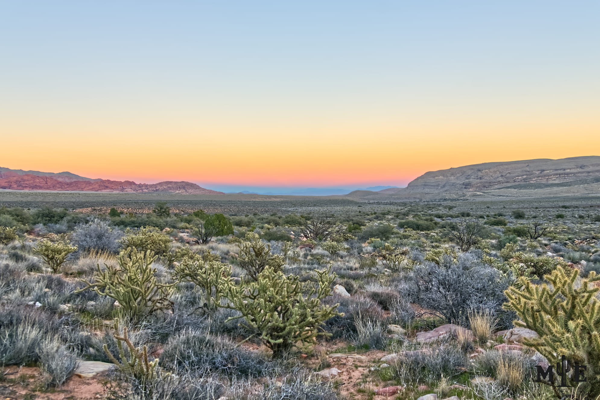
The Mojave Desert is one of North America’s most recognizable landscapes, yet it's often reduced to an image of empty ground between Los Angeles and Las Vegas. In reality, its a varied high desert spanning southeastern California, southern Nevada, northwestern Arizona and southwestern Utah. It contains the lowest, hottest basin on the continent, snow-covered mountain summits, dry lakes, volcanic fields, dunes, Joshua tree woodlands, springs, cities and cultural landscapes shaped by thousands of years of human life.
A practical way to recognize the Mojave is through the Joshua tree. The species is native to the desert and grows mainly within its boundaries and transition zones, usually at elevations cooler than the lowest creosote flats. It's an indicator rather than an absolute border marker: ecosystems blend, and the Mojave meets the Great Basin to the north, the Sonoran Desert to the southeast and lower Colorado Desert environments to the south. Mojave National Preserve contains elements of three major deserts because elevation, soil and water create overlapping habitats.
Elevation is the reason the landscape changes so quickly. In low basins, creosote bush and white bursage stand widely separated across gravelly ground. Higher slopes can support blackbrush, Joshua trees, Mojave yucca and cactus. Pinyon-juniper woodland appears above them, while isolated high mountains may contain fir, ponderosa pine or bristlecone pine. Mojave National Preserve ranges from roughly 800 feet to nearly 8,000 feet, producing life zones that would seem unrelated if they were not compressed into one region.
The climate is famous for heat, but “the Mojave is hot” is only a partial description. Death Valley’s Furnace Creek holds the official world record of 134°F, recorded on July 10, 1913, and summer shade temperatures there often exceed 120°F. At higher elevations, winter lows can fall into the 20s, and snow can cover Joshua trees, Red Rock Canyon or the Spring Mountains. A person can leave a mild Las Vegas neighborhood and encounter icy trails after a relatively short climb.
The desert exists partly because mountain ranges strip moisture from Pacific storms. The Sierra Nevada and other California mountains force air upward, where much of its moisture falls before the air descends toward Nevada and the interior Southwest. Annual precipitation is low and irregular. Long dry periods can be interrupted by violent storms that produce flash floods, reshape washes and close roads. Water is scarce in total volume but powerful when concentrated.
Plants survive through strategies rather than simple toughness. Creosote shrubs spread shallow roots to capture brief rainfall. Cacti store water and reduce exposed leaf surface. Joshua trees provide nesting and shelter for birds, insects and small mammals. Around springs and seeps, cottonwoods, willows, velvet ash, grasses and other riparian plants form narrow green corridors that support far more wildlife than their acreage suggests. These water sources have always been critical to animals and people.
Much of the Mojave’s wildlife avoids the hours when visitors are most likely to look for it. Kangaroo rats, kit foxes, bats and many reptiles are active at night or during cooler periods. Coyotes adapt to nearly every habitat, while desert bighorn sheep use steep rocky terrain as protection. Roadrunners, Gambel’s quail, ravens, owls and migrating birds occupy different parts of the desert. Joshua Tree National Park alone has recorded dozens of mammal and reptile species, including multiple rattlesnakes.
The desert tortoise may be the Mojave’s most important wildlife symbol. It spends much of its life underground, emerging when temperature and moisture conditions allow. The animal is federally protected, and populations have declined because of habitat loss, roads, disease, illegal collection and other pressures. A tortoise should not be touched, carried or relocated unnecessarily; contact a local agency if one is in immediate roadway danger.
The Mojave has never been an unoccupied wilderness waiting for modern discovery. Archaeological evidence and living traditions document at least 10,000 years of human connection in places now managed as Mojave National Preserve. Mojave people lived along and traveled from the Colorado River, using a major east-west route later called the Mojave Trail. Chemehuevi communities lived across mountain, lake and desert areas, while Southern Paiute people used lands extending through southern Nevada and surrounding regions. These are distinct peoples with distinct histories, not one generalized “desert tribe.”
Rock writing, tools, roasting pits, trails and settlement sites preserve part of that history. Red Rock Canyon contains petroglyphs, pictographs, agave roasting pits and evidence of repeated seasonal use. Sloan Canyon protects more than 300 rock-writing panels with roughly 1,700 designs. Valley of Fire, Gold Butte and Colorado River landscapes also contain major cultural resources. These places should be approached as living cultural landscapes, not outdoor galleries available for touching, climbing or collecting.
European and American travel added new layers. Spanish and Mexican trade routes crossed parts of the region, including the Old Spanish Trail. Later surveyors, soldiers, miners, ranchers and railroad companies followed water sources and Indigenous travel corridors. The Mojave Road developed from a Native trade route connecting springs between the Colorado River and coastal California. Mining camps, rail structures, homesteads and military sites remain scattered across the desert, but their ruins do not replace the much longer Indigenous history beneath them.
Las Vegas is the Mojave’s largest urban expression. The city’s towers and freeways can conceal the setting at street level, but surrounding geology remains visible from almost everywhere. Red Rock Canyon rises west of the valley in red Aztec Sandstone and gray limestone. Sloan Canyon and the McCullough Range form the southern edge. Lake Mead and the Colorado River lie east, while the Spring Mountains climb high enough to support forests and winter snow. Las Vegas is not beside the Mojave; its a major city built within it.
Red Rock Canyon is one of the desert’s most accessible protected landscapes. Its sandstone cliffs formed from Jurassic dunes, and its springs concentrate plants, wildlife and human history. Valley of Fire displays red sandstone arches, narrow passages and rock art northeast of Las Vegas. Gold Butte National Monument protects nearly 300,000 acres of rugged Mojave terrain, colored sandstone and cultural sites. Farther south, Avi Kwa Ame National Monument protects land sacred to numerous Tribal Nations where Mojave, Sonoran and Great Basin influences approach one another.
Mojave National Preserve in California presents the desert at continental scale. Its approximately 1.6 million acres contain the Kelso Dunes, Cima Dome, lava flows, cinder cones, dry lakes, historic roads and one of the world’s largest and densest Joshua tree forests. Joshua Tree National Park protects a transition between the Mojave and Colorado deserts, while Death Valley shows the Mojave at its lowest and most extreme. These places explain why the desert is internationally known: their landmarks are radically different but connected by climate, elevation and adaptation.
Basin and Range National Monument is sometimes grouped casually with Mojave destinations because it's about two hours north of Las Vegas and shares Nevada’s alternating mountains and valleys. Geographically, however, it protects one of the least disturbed parts of the broader Great Basin region. It's not a central Mojave landscape. The distinction matters because Southern Nevada sits near ecological boundaries where desert systems approach or overlap.
The spelling question reflects history rather than two different deserts. “Mojave,” with a j, is the standard spelling used for the desert and by the Mojave Indian Tribe. Historical records also used “Mohave,” and that form remains in established proper names such as Fort Mohave and Mohave County, Arizona. Schools, businesses and brands may retain the h because of local history or naming preference. Mohave Edge therefore does not imply a different desert; it uses a legitimate historic regional spelling as a brand name.
The Mojave is famous partly because millions of people encounter it. Interstate highways, Route 66, railroads and air routes cross it between major western cities. Films, advertising and music use its long roads, Joshua trees and dry lakes as shorthand for distance, danger, freedom or isolation. It contains globally familiar destinations while preserving enormous areas where darkness, silence and open horizons dominate. Few deserts place such severe-looking wild country so close to a metropolitan center as large as Las Vegas.
Its apparent durability is misleading. Vehicle tracks can remain visible for decades, biological soil crust is easily destroyed, and slow-growing plants may not recover within a human lifetime. Invasive annual grasses create fine fuel that allows fire to spread through plant communities not adapted to frequent burning. Development fragments habitat, groundwater use affects springs, and a warming climate intensifies heat and drought stress. Conservation is not about protecting emptiness. It's about protecting relationships among water, soil, cultural places, migration routes and organisms surviving within narrow limits.
The peaceful basin in this photograph contains that complexity even when no animal, road or person is visible. Sunset softens the desert, but it does not make it simple. The Mojave is a place of extremes and subtle life: ancient routes beneath modern cities, snow above heat-shimmered valleys, springs hidden among dry ridges and communities adapted to conditions that seem impossible from a distance. Its fame comes from spectacle. Its importance becomes clear only when the landscape is examined closely.
Prints, Artwork and Licensing
This photograph is available for project-specific review as finished wall artwork and for appropriate editorial, commercial, hospitality, corporate, healthcare, or civic licensing. Final dimensions, cropping, materials, usage, production, and installation requirements are confirmed for each project.
Use the inquiry button above and reference ME-00384 so the exact image can be identified quickly.


